aa…
approximately at 10.26 pm. got tremors felt at KL sky craper building..
one at menara orkid and kg baru reported to have feel it..
from international news..
Earthquake Details
| Magnitude | 6.2 (Preliminary magnitude — subject to revision) |
|---|---|
| Date-Time |
|
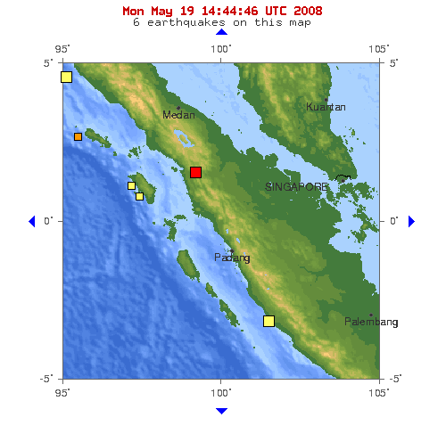
| Location | 2.000°N, 99.200°E |
| Depth | 38 km (23.6 miles) set by location program |
| Region | NORTHERN SUMATRA, INDONESIA |
| Distances |
|
| Location Uncertainty | Error estimate not available |
| Parameters | NST=010, Nph=010, Dmin=104.5 km, Rmss=0.16 sec, Gp=130°, M-type=moment magnitude (Mw), Version=1 |
| Source | |
| Event ID | at00120721 |
- This event has been reviewed by a seismologist.
http://earthquake.usgs.gov/eqcenter/recenteqsww/Quakes/at00120721.php
and..
after few minute .. kjc confirmed that..as
Earthquake/Tsunami Alert ( IDM20024 )
10:35 malam, 19hb Mei 2008
Our Ref: JMM.APL15/442/19 Jld ( 17e )/ ( 80 )
| PRELIMINARY EARTHQUAKE INFORMATION Issued by Malaysian Meteorological Department Ministry of Science, Technology & Innovation at 10.35 pm 19/05/2008 |
||||||||||
|
but later.. USGS provide a new one.. which has buzz my email..
5.9 Mw – NORTHERN SUMATRA, INDONESIA
| Magnitude | 5.9 Mw |
| Date-Time |
|
| Location | 1.646N 99.181E |
| Depth | 11 km |
| Distances |
|
| Location Uncertainty | Horizontal: 8.8 km; Vertical 40.8 km |
| Parameters | Nph = 81; Dmin = 434.3 km; Rmss = 1.07 seconds; Gp = 46° M-type = Mw; Version = 6 |
| Event ID | US 2008sfa9 ***This event supersedes event AT00120721. |
For updates, maps, and technical information, see:
Event Page
or
U.S.G.S. Earthquake Hazards Program
National Earthquake Information Center
U.S. Geological Survey
http://neic.usgs.gov
Disclaimer
This email was sent to [email protected] You requested mail for events between -90.0/90.0 latitude and 180.0/-180.0 longitude for M5.5 at all times. To change your parameters or unsubscribe, go to: http://earthquake.usgs.gov/eqcenter/ens